
All photos © Toby Speight
Liar’s Sink is the name given to an obvious sink in the burn a short distance from the Cave of the Liar, Applecross. The following account is drawn from Toby Speight’s description of its exploration between January 2016 and October 2017. The original account, along with more pictures, can be found on the cave’s dedicated website. We are grateful to Toby for allowing us to republish this work.

Although I’d known for nearly ten years that the burn sinks a short distance upstream of Cave of the Liar, it had always looked inpenetrable underneath the cold water. It wasn’t until January 2016 that I saw it in dry conditions and looked more thoroughly. After visiting the water intake for the new hydro-electric scheme, Gwenllian Tawy and I were on our way to dig in Nightmare Passage when we stopped to look at the sink. With no water flowing, we were quickly able to burrow down and see the beginnings of an ongoing rift below us. We dug down to about -2m, using the larger rocks to construct a small wall to divert the burn away from the hole.
Other projects occupied my attention, and the sink was languishing in the back of my mind when, in early October, Alex Latta mentioned that he’d been digging in the burn. After some discussion, our descriptions of the area finally tallied, and we discovered that our efforts had been just two metres from each other! This inspired me to return and actually try to enter the rift. I hoped it might be a back way in to the Nightmare Passage dig, to bypass 40m of tortuous (and torturous) crawling. The following weekend, 10th October, I recruited new GSG member and novice digger, Saber King, and we had an enjoyable day’s digging. We extracted a few more boulders and lots of gravel and cobbles, but destroyed our bucket and severely injured the one that we stole from Alex’s stash. We hadn’t made any forward progress, but there was now room to dig, and we could properly see into the rift, which seems to head westwards, towards the entrances of Cave of the Liar.
Now that the bug had bit me, I recruited a different novice digger for the following weekend. Jessica Morin-Buote is a Canadian student on a 4-month exchange visit to Scotland, and she accompanied me, with replacement buckets and two crowbars, on Saturday 17th October. We hoisted out some big rocks (having to return to the car to fetch the ratchet winch for those to big to move by hand). After about 4 hours, Jessica was digging an alcove on the south side of the hole – not towards Cave of the Liar, but I didn’t mind as it was increasing our manoeuvring and stacking space. She shouted up that it was empty beyond, and she could see a bend, perhaps connecting more easily with the rift we were chasing. When it was my turn to dig, I discovered that as well as seeing blackness beyond, I could feel a significant draught coming through. The game was on! Jessica was at the front when we had opened it enough to enter. As her feet disappeared, I shouted to ask if it was big enough to follow. I soon discovered that it was, and we excitedly explored the passage, expecting at every bend to find it pinching out or solidly choked. But it just kept going, sometimes flat out, but often hands-and-knees height, with some straws here and there for scenery. “Can you hear that?” It sounded like water, and sure enough, after a few metres we came to a junction with a streamway. I suggested to draw lots for the upstream and downstream exploration rights, but we soon discovered that downstream had little to offer. Within a body length of the junction, the water disappeared under a choke that in turn supported high mud banks. Nothing for us there today.

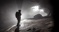
Turning our attention upstream, we found that the passage was wide enough for two, though extreme care was needed to protect the formations. Almost immediately, we found a beautiful calcite grotto, then we needed to climb very carefully over boulders and under straws, following the stream upwards. We looked in a few oxbows, seeing each other’s light but not entering in our muddied suits. After a lower section of passage, we came to a boulder heap that looked like the start of a choke, but climbing up, we popped out into a substantial chamber, which must be the tallest and widest in Wester Ross. We estimated it at ten metres high and were later to measure it as 7×17 m. Connected to this chamber at top and bottom is another chamber of similar height, but perhaps one-third to one-half the area. The water comes in from high above, beyond our reach, so that was our limit. On the way out, we followed an oxbow passage from the big chamber (which we named Canada Cavern) to the streamway and estimated about 20m. In all, we guessed we’d found over a hundred metres.
Jess’s next lesson in digging came the next day: if you find something, it’s your responsibility to document it. So we returned on Sunday, with survey instruments and camera. We surveyed in (but ignored the oxbow that was too delicate to re-visit) and photographed out (until we exhausted the camera battery). We measured 185 m of centreline, and noted several oxbows and inlets. We returned with a bigger and better (and, more importantly, fully-charged) camera a few weeks later. The stream was sinking in the adjacent Waterfall Dig, but the entrance crawl was passable (albeit uncomfortable). For comparison, Uamh nam Fior Iongantais was brim-full but flowing through (rather than over) the entrance rockery.
The next visit, on 26th November, was with Gwenllian Tawy, David Morrison and Richard Simpson. We first had a good look around the downstream choke, discovering the Upstairs Series of well-decorated dry passage above the stream junction. Then we carried a maypole to Canada Cavern and climbed up to the roof overlooking Waterfall Chamber, where we could see a good-sized inlet passage. This could not be reached, so had to be left for future exploration.
A number of visits were made in December and January. The maypole climb was equipped with a knotted handline, the chambers and oxbow were surveyed, some inlets investigated and an attempt made to pass the downstream boulder choke. On the surface, I spent an afternoon re-building the entrance climb with a retaining wall, David, Ritchie and Jane conducted some dye tests, and much work was done to re-model the stream bed to reduce ingress into the entrance passage.
In February 2017, I visited with David Morrison and Jane Stewart-Bollen, with the intention of crossing the head of Waterfall Passage to follow its inlet water. On my surveying trips, I’d spotted a one-metre band of limestone along the top of the chamber, that might accept bolts – that seemed much more achievable than the idea of trying to construct an angle-iron bridge across the gap. I entered with a bag of bolts and hangers, and Roger’s cordless drill. Despite my limited experience of expedition rigging, I was the best available resource, so we had to make do. With assistance from the others, I placed a pair of good anchors, and then slowly worked my way across to the waterfall, placing three more bolts on the way. The good rock ended, and I was still a metre away from anything that looked like a foothold. A futile attempt at a pendulum got me nowhere (but did increase my confidence in the bolt placements), so I tried a more stealthy tactic. I hung up everything heavy and stretched across, grabbing bits of the ledge (most of which came away in my hands, but some held). Eventually I was able to wriggle onto it, like a seal climbing a rock, and work my way into the passage beyond.

Now I was on the other side of the gap. I didn’t know whether it would be possible to get back, but first I should go exploring. After a short narrow section, I reached a small chamber with a pool; from there was stomping passage leading for at least 60 m eastward. I stopped when I reached a roof collapse, acutely aware that I was on my own and in no position to take any risks. Arriving back at the pitch, I was able to anchor my end of the rope to a block several metres back, giving a bouncy but reasonably safe traverse back. Jane was shivering, so I didn’t place the final bolts, leaving them for Sunday, and we made our way back to the surface and a celebratory drink in the Inn.
Sunday saw both me and David back in the cave, this time accompanied by Imogen Furlong and Mike Todd. Imo’s greater experience of expedition caving helped improve my rigging. I placed the far-end anchors and invited David and Imo to follow me across (Mike was less keen, having the wrong harness for dangling). I let them head up to push my previous limit, while I managed a page of surveying.
The survey finally caught up with exploration in early March; the 11th of the month saw me back in the upper passage (now called Shale Highway) with David and Ritchie, pushing the remaining leads and measuring up. Any further progress now required actual digging, rather than just being nosy and fearless.
In mid-April, Steve Gray from the Red Rose came to visit; a further 15m of flat-out crawl was pushed through the upstream boulders, but we failed to regain open streamway. Later in the month, Alex and Derek revisited the Waterfall Dig, and pushed it to a visual connection with Skull Corner. I think David was involved with this, but wasn’t present myself. The dig name was replaced with a real cave name: Uamh nan Tuil, or Flood Cave.
The end of May saw a large GSG contingent descend on Applecross, with both of the caves (and others in the area) seeing several visits. Mike Todd and I managed the first through trip from Flood Cave to Liar’s Sink (though this didn’t involve any new ground). I went with Mike to survey the previous month’s pushing over the boulders; at the end of the survey I found the inlet passage was a duck, and after just two metres found over 80 metres, starting with a hands-and-knees streamway and reaching a substantial wide chamber. This was surveyed at the end of August, and the side passages of Uamh nan Tuil added in October.
At the end of October, May and Ben visited and became the first to join me through the Tollbooth duck and through the Wallows to reach the Sanctuary.
The surveyed length is 598 metres, with a vertical range of 25 metres. We suspect that the water that flows through the cave may be that which comes into Cave of True Wonders. Dye tracing is in progress to establish the full hydrology of the catchment.

(Correspondent:Toby Speight)