
The backbone of cave surveying is the data, in other words the numbers. We spend many hours collecting them, and some time building up pictures around the numbers. This means that as computers became a home item, cave surveyors rapidly adopted them to carry the burden of the tedious after-caving task of crunching the numbers. In recent years, we have also moved this technology into the cave and with it the surveying has continued to improve. However, getting in at the start of something generally means that most of the things you do have to be developed from scratch.
Survex, and later Therion (which builds on Survex), are excellent examples of software that has been developed for caving and are therefore wonderfully tuned to the needs of cave surveying (although some might argue that the front ends could be better or even exist at all!). Over time, other software began to catch up and as computers became more powerful, it became easier to get around the complexity of surveying large systems using off-the-shelf software like Illustrator. Both of these methods (using cave-specific software and off-the-shelf software) have some advantages. The specific cave software ‘understands’ cave data and can use it for multiple outputs, like a drawn plan and plotting a 3D model in relationship to another cave, with the surface shown from a satellite image. Drawing programmes like Illustrator are easy to learn, show you exactly what you have and are getting, and the outputs can easily be exported to other things.
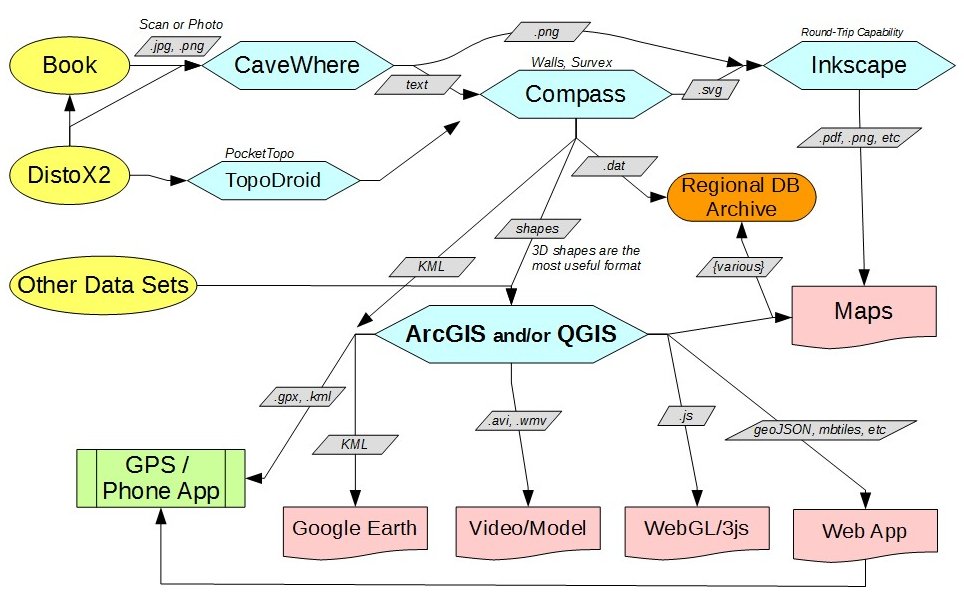 Surveying is now changing rapidly, or certainly looks like it is about to. 3D laser scanning is growing and photogrammetry or image from motion is getting there, together with all the additional data that can be collected when surveying, like the photos, that now number thousands on every expedition. All the track logs of where everyone walked are getting collected more often, not to mention the traditional logbooks that more and more people would like to be able to combine with the survey and cave description. But cave surveying software is just not keeping up. Add in all the other information that is now available and rapidly updated, like the surface height and declination, which can be watched to vary by the hour (so maybe an exact time of a recording should be taken…). Most of this non-caving data can be handled by non-caving software, but to utilise it, most caving software cave data has to be exported and quite often tediously rearranged or vice versa. So it rarely gets done.
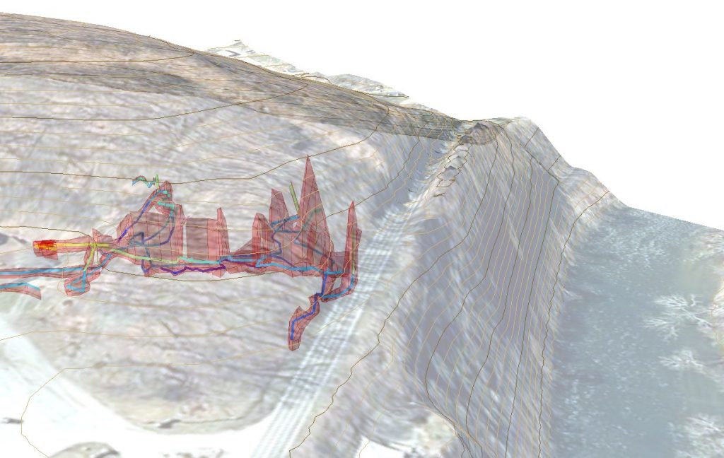
Non-caving software has had the same problems, where everyone appears to have gone down the same route of solving their own problems in their own way. However, this is changing and with more resources other groups are making big inroads and producing software that might be useful to caving. Geographic Information Systems (GIS) used to be very good at surface maps and storing data and photos, however, as more information has become available and fancier graphics demanded, the software has developed into a 3D utility. Caves are part of the geographic landscape and most of the non-cave surveying data appears to be able to understood by the majority of GIS software. Some cavers, like Mike Futrell, are already exporting data from cave software and using it to get good outcomes, which is where the pretty picture at the top comes from. The problem is, every time the cave survey changes the whole lot needs to be imported again. GIS software, especially some of the open source ones like QGIS are modular and therefore can be modified. So the question is can this be done so that cave data can neatly be integrated into GIS? If so, what needs to be done?
If this is to succeed it will need knowledge from lots of different places, the two main camps being people who know how to use GIS and people who know cave surveying software well, but at the moment these two areas seem to have very little overlap. It would be good to get people together to start a discussion on this, so to this end I have arranged a discussion time (workshop) to be held at Hidden Earth 2017, please come along, share your insights, or just keep up with what is going on.
Correspondent: Andrew Atkinson